
Dolpa is a high-altitude region in western Nepal, set beyond the main Himalayan crest. It lies in the rain shadow of the Himalaya (being blocked by peaks like Dhaulagiri) and has a semi-arid climate with very little rain. Elevations range roughly from 2,100 m in low river valleys up to over 6,800 m on the Tibetan border. Dolpa is culturally Tibetan and Buddhist, with ancient Bon traditions preserved in these remote valleys. The sparse population (a few tens of thousands) is mainly agro-pastoral farmers and herders. In spring and summer, they move livestock to high alpine pastures (a practice called samadrok). At lower elevations, they grow barley, millet, and potatoes by irrigation.
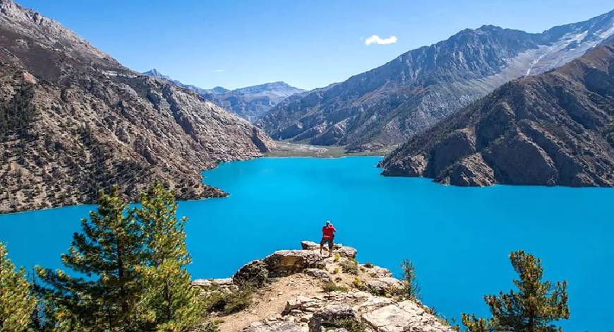
Dolpa is usually described as Upper Dolpa (northern high valleys) and Lower Dolpa (southern valleys). Both are part of Shey Phoksundo National Park, Nepal’s largest Himalayan national park (3,555 km²). The park covers rugged mountains (up to 6,883 m at Kanjiroba Himal) and deep gorges. Famous lakes and wildlife are found here. For example, the deep turquoise Phoksundo Lake is a highlight – at about 3,660 m elevation, it is noted for its brilliant color. (In fact, it is one of the deepest lakes in Nepal.) Phoksundo’s clear water is surrounded by cliffs and waterfalls, making it very scenic. Its water surface is about 4.94 km² and it reaches ~145 m. (Phoksundo Lake was declared a Ramsar site in 2007.) Dolpa is also home to rare animals – snow leopards, Himalayan wolves, musk deer, blue sheep, and Himalayan tahr roam these slopes. A recent study counted over 90 snow leopards in Shey Phoksundo National Park, a reminder of the wild character of this region.
Other lakes include smaller high ponds and tarns, but many trekkers also combine a Dolpa journey with nearby Rara Lake. Rara Lake lies west of Dolpa in Jumla–Mugu District and is Nepal’s largest alpine lake. At about 2,990 m altitude and with a maximum depth of ~167 m, Rara is famous for its beauty and forested surroundings. It is the centerpiece of Rara National Park, and a peaceful destination to Rara Lake is a common extension after trekking in Dolpa.
Culture and Traditions
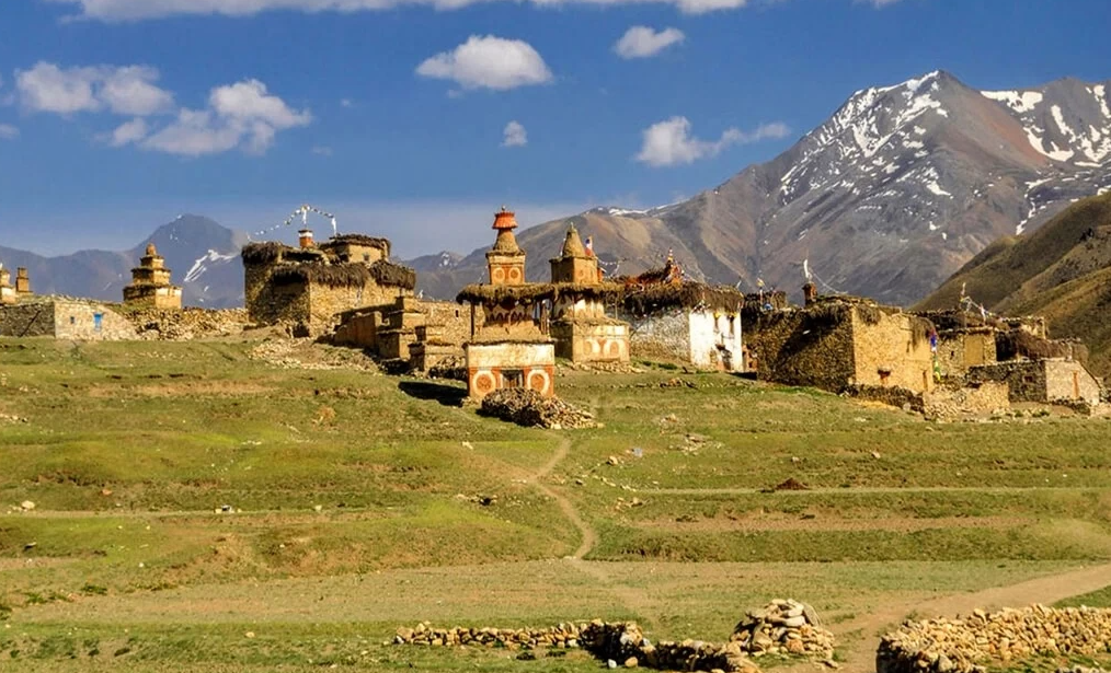
Dolpa’s people (the Dolpo-pa or Dolpopa) speak Tibetan dialects and practice Tibetan Buddhism mixed with older Bon beliefs. They built red ochre gompas (monasteries), whitewashed chortens (stupas), and houses of stone and mud. Life is simple and traditionally self-sufficient. A key custom is the samadrok migration – families move with yaks and goats from village fields up to high summer pastures (4,000–5,000 m) to graze livestock. Barley (the staple grain) and yak cheese are important foods. The Dolpa way of life has changed little in centuries, which attracts travelers seeking an unspoiled Himalayan culture. The Oscar-nominated film Himalaya (1999) was even set here, showing villagers’ nomadic salt-trading caravans and mountain festivals.
Unique local traditions include festivals, handicrafts, and trade links to Tibet. The whole area was once part of a trans-Himalayan salt-trade network, exchanging Tibetan salt for Nepali grains. Dolpa’s people also gather wild yarsa gompa fungus each spring. These caterpillar-fungus mushrooms (sometimes called “Himalayan Viagra”) fetch high medicine prices. The spring pastures – sometimes called Yarsha Gompa Valley by trekkers – bloom with alpine herbs, and the Dolpa collectors camp high in the meadows to harvest yarsa. In this way, the region’s ancient subsistence lifestyle meets a modern cash income.
Natural Wonders and Landscapes
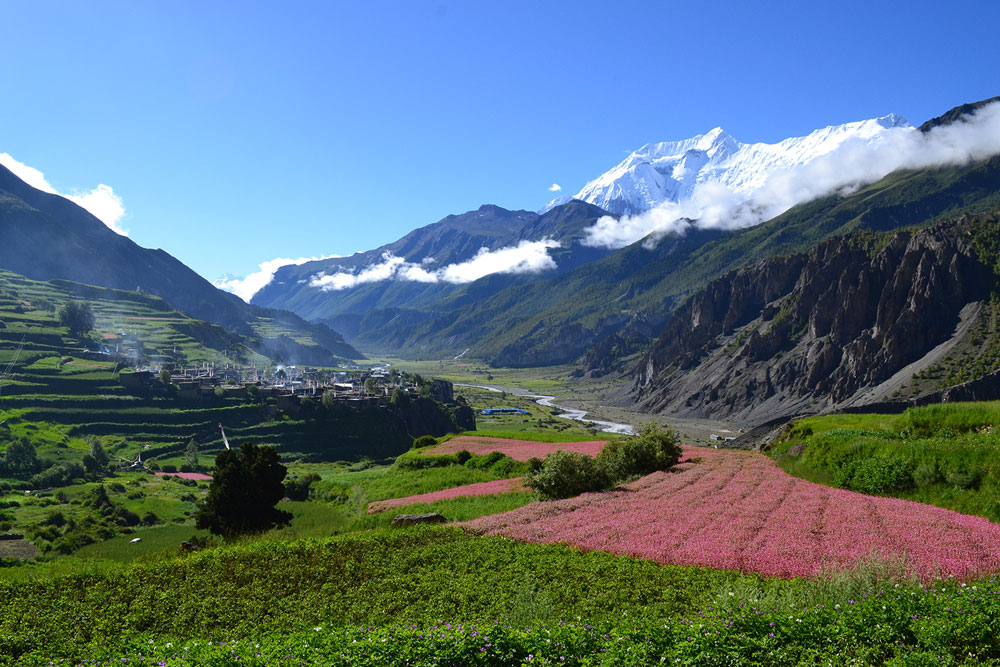
Dolpa’s scenery is raw and spectacular. Much of it looks like the Tibetan Plateau: wide valleys of scrub and grass, frozen lakes, and peaks bigger than the tree line. To the south, the Dhaulagiri range towers with glaciers that feed deep canyons. In the dry Tarap and Phoksundo valleys, barley fields and juniper scrub mingle with birch forests. To the north, the world abruptly rises to giant peaks on the Nepal–Tibet border (up to ~6,500–7,000 m). Many peaks are unnamed or seldom climbed. One prominent mountain near Shey Gompa is Shelri (often called Crystal Mountain), a sacred 6,000+m summit that looms over the monastery.
Other scenic highlights include Panjara and Kanjiroba Himal, broad upland pastures, and hidden glaciers. The Shelri-Ghar range (part of Dhaulagiri) has the highest peaks in Dolpa. Valleys like Tarap are open and green in summer, with barley rippling to the horizon. Waterfalls in remote gorges (especially above Phoksundo Lake) are impressive in the melt season. In autumn (September–October) and spring (March–May), the weather is generally clear and dry, offering the best trekking conditions. In winter, it is extremely cold and inaccessible. The monsoon rains rarely reach Dolpa, so even July–August has mostly clear skies (though occasional storms can hit).
Spiritual and Cultural Sites
Dolpa is dotted with Buddhist sites and sacred places. The most famous is Shey Gompa (She Gumba), the “Crystal Monastery” in Upper Dolpa. Perched at ~4,200 m, Shey Gompa was founded in the 11th century and is regarded as the spiritual heart of this region. Its name means “Crystal” (Shelri) in Tibetan, and it looks out upon the shining peak of Shelri/Gompa Ri (the Crystal Mountain). Once every 12 years (in the Year of the Dragon), the monks and villagers hold the Shey Festival at this monastery. During Shey Mela, pilgrims perform a kora (circumambulation) around the mountain peak, much as one would around Mount Kailash. This festival draws hundreds of Buddhists from across the Himalaya, who come to chant, pray, and dance in the high valley.
Near Shey, visitors will see prayer flags and mani stones along trails. Other important gompas include Nesong (Nissle) Gompa and Yarsha Gompa, smaller red monasteries tucked into valleys. (Dolpa has dozens of such remote gompas, some nearly 1,000 years old.) In Phu Village up north, a tiny hamlet on a high ridge near Tibet, there is a simple monastery and stupa. Trekkers often note the “Phu Village Cross” – a wooden cross or marker near the monastery (symbolic of a crossroads in the trade route) that stands as a local landmark. (Phu’s monks are known for their hospitality and butter tea.)
Dolpa also has many caves and meditation spots. Local lore holds that Buddhist saints like Milarepa meditated in this wilderness. One such site (sometimes called the Melarapa Meditation Cave) is said to be a yogi’s retreat high above a valley. Pilgrims may visit small prayer caves and chortens perched on cliffsides. Even without formal maps, trekkers encounter mani walls (built of stone inscribed with prayers) in lonely spots, the sign of ongoing religious practice.
Villages like Bhijer, Saldang, and Chharka have their heritage. Saldang (in Nangkhong Valley) is one of the larger Upper Dolpo villages, with white-brick houses and nearby older gompas adorned with murals. Tinji and Shimen are large winter herding camps. In Lower Dolpa, Tarap Valley towns like Dho-Tarap and Lower Dolpo temples (like the Ningmec Lineage gompa at Dolpa’s gateway) blend Tibetan and Nepali culture.
Trekking Routes and High Passes
Dolpa is one of Nepal’s most remote trekking regions, so any visit is an adventure. The treks often start from Juphal (Dolpa’s airport) or Dunai (the district headquarters), reached by flight or jeep from Kathmandu or Nepalgunj. From Juphal, trails climb into deep gorges toward the inner valleys. Phoksundo Lake is a common early stop on the Lower Dolpa trek. After the lake, hikers climb high passes to enter the Upper Dolpa region.
The Upper Dolpa Circuit (often 20–30 days) is strenuous because it crosses many 5,000m passes. For example, one popular route goes from Juphal north to Bhijer, then west to Shey Gompa, over passes into Tokyu, and rejoining Lower Dolpa near Phoksundo. Along the way, trekkers live in stone pasture huts (“gairighar”) or small villages. Trails may be rough or rocky, so good fitness and preparation are essential. Tenting or staying in basic tea-houses is the norm, since hotels are scarce.
Key high passes and routes include:
- Nima Gyeljen Pass (around 5,000 m) – leads north-west from Dolpa into Mugu District. Local traders once used it to reach the Karnali foothills. (It lies near Bhijer.)
- Kang La (5,360 m) – a major pass entered early on some Upper Dolpa routes. It leads from the Tarap Valley into Inner Dolpo.
- Numa La (Numala Pass, 5,238 m) – this pass connects Lower Dolpa (above Tarap) to Upper Dolpa valleys. It is one of the highest points on the standard Lower Dolpa trek.
- Baga La (Bagala Pass, 5,169 m) – another high pass just south of Numa La; also on the Lower Dolpa trek. From here, one drops down to Ringmo and Phoksundo.
- Tantala Pass (often spelled Tantala or Tantalapass) – an unnamed ~5,000 m pass used on extended treks from Upper Dolpa toward Mustang or Rara. (This is a rough roadless pass in the Dolpo–Mustang region.)
From the passes, trekkers enjoy wide views of Dolpa’s mountains. For example, the Kang La summit overlooks snowy peaks and valleys of Tibetan yak herders. Many treks include Nangla (Gangla) or Tokyu passes and variations. As one popular guide notes, “the route rewards travelers with breathtaking vistas and heartfelt encounters with the warm Dolpo-pa people”. It is common to see yak caravans or isolated chortens on the high ridges.
Most trails are marked by cairns or ropes, but there are no lodges above 4,500 m. Trekking in Dolpa is considered strenuous: one outfit grades it as crossing six 5,000m passes with rough trails. Hikers need to be well-acclimatized and carry warm gear. In autumn and spring, the trails are usually clear; in mid-summer, snow may linger on the highest passes.
Popular itineraries:
- Lower Dolpa Trek (about 15–20 days): Flies into Juphal – trek via Dunai, Laini, Do-Tarap to Phoksundo Lake – cross Numa-La and Baga-La – descend to Ringmo and then back to Juphal. (This covers all Lower Dolpa highlights.)
- Upper Dolpa Circuit (20–30+ days): Reaches Bhijer or Tarap – crosses Kang La – visits Shyamling Gompa and Shey Gompa – goes to Saldang and Phu Village – descends via Kagmara/Tantala back toward Jomsom or Mugu. (Some treks loop onto Mustang or Rara).
Many trekkers combine Dolpa with other regions. For instance, one may continue to Rara Lake after finishing Dolpa, or enter Upper Mustang by one of the northwestern passes. However, these detours add weeks.
Practical Travel Tips
Permits
Dolpa is a restricted area. All foreign trekkers must carry a special Dolpa permit. The cost is high: Upper Dolpa allows about 10 days for US$500, then ~US$50 per additional day. Lower Dolpa is cheaper (about US$20 per week. Permit rules can change, so check with Nepal’s Department of Immigration or your trek organizer. Guide requirement: Government regulations require that trekkers hire a licensed guide and/or porter for Dolpa.
When to Go
The best seasons are spring (March–May) and autumn (September–November). These months have stable weather and clear skies. Summer (June–August) is warmer but may have occasional rain or clouds; roads and flights can be easier then, but higher passes may see lingering snow. Winter (December–February) is very cold and trails are often blocked by snow.
Altitude
Dolpa’s villages range from ~2,500 m (Dunai) to 4,000+ m. Proper acclimatization (rest days, gradual ascent) is important to avoid altitude sickness. Spend a day in Dunai or stay a night at 3,500 m before pushing higher. Drink plenty of fluids and be prepared for cold nights (down to –10°C or lower at altitude).
Health and Safety
There are no hospitals or medical facilities in Inner Dolpo. Carry a well-stocked first-aid kit. Altitude illness is the main concern; know the symptoms and descend if serious signs appear. Insurance and an evacuation plan are recommended.
Local Customs
Dolpa’s people are very hospitable but traditional. Always ask before photographing villagers or taking pictures at monasteries. Remove shoes and hats in gompas and private homes. Trekkers are welcome to drink yak butter tea with families in summer yak camps (in Dolpo, it is polite to accept small offerings of tea or chang). By contrast, it is polite to keep a distance at religious events unless invited. Respect the environment: Dolpa’s ecosystems are fragile. Carry out all trash, use refillable water containers, and camp at least 50m from water sources.
What to Pack
Warm layers (fleece/shell), good trekking boots, a warm sleeping bag (0°C or lower rating) for high camps, and rain gear. Sun protection is vital (sunglasses, hat, sunscreen) at high altitude. Streams can be forded, so gaiters or sandals are useful. Trekking poles help on rough terrain. A headlamp is handy since electricity can be scarce. Porters and/or pack animals (yak or mule) are essential for carrying gear, as there are no road vehicles in Upper Dolpa.
Travel Logistics
The journey often begins in Kathmandu or Pokhara and flies to Nepalgunj. From Nepalgunj, you can fly to Juphal (Dolpa’s small airport) in about an hour. (Be prepared for flight cancellations if the weather is bad – there are mountains under the clouds.) Alternatively, buses or jeeps run from Nepalgunj to Dunai (2–3 days), and a chartered jeep can sometimes go all the way to Juphal. Many trek routes either start or end in Jomsom (near Lower Mustang), accessible from Pokhara, or connect to Rara via roads from Simikot. If you fly out of Juphal or Simikot at the end, book those flights in advance, as seats are limited.
Culture Tip
Dolpa’s local dialect is called Dolbo or Dhol-wa (a form of Tibetan). Nepali is understood in markets/towns. English is rare. A few words of Nepali or even Tibetan greetings (like “Tashi Delek!”) go a long way. When visiting monasteries, be quiet and do not interrupt ceremonies. The Shey Festival (if you happen to travel in the Year of the Dragon, next 2036) is an extraordinary experience – but plan months or years ahead for that.
Summary of Highlights
- Shey Gompa (Crystal Monastery) – Iconic 11th-century gompa at 4,200 m, center of the Dolpa Buddhist heartland. Hosts a rare 12-year festival (most recently in 2024) celebrating the Crystal Mountain (Shelri) around it.
- Phoksundo Lake – Turquoise alpine lake (3,660 m) in Shey Phoksundo NP. Nepal’s second-deepest lake (145 m). Surrounded by pines, barley fields, and cliffs with sacred deer.
- Tibetan Villages – Villages like Bhijer, Saldang, Tinje, and Phu retain Tibetan architecture and customs. Many have gompas or chortens with painted walls.
- Yarsha Gompa Valley – Region of high pastures known for the wild caterpillar fungus (Yarsagumba) collected each spring. The name comes from Yarsha Gompa, a famed local mushroom (literally “caterpillar herb”).
- High Passes – Dolpa trekking is famous for its passes: Nima Gyeljen Pass (northwest exit), Kang La (5,360 m), Numa-La (5238 m), Baga-La (5169 m), and others like Tantala/Tantala Pass (~5050 m). Each offers grand mountain panoramas (Dhaulagiri, Kanjiroba, Annapurna range to the east).
- Rara Extension – Trekkers can continue from Dolpa to Rara Lake (3,000 m), Nepal’s largest lake, to see dense forests and distant Saipal Peak. This is a separate national park but is often paired with Dolpa trips.
Dolpa’s beauty lies in its isolation: turquoise lakes, red monasteries on barren slopes, and nomads riding up steep valleys. Trekkers who come here talk of “big sky” scenery, unhurried villages, and a sense of peace. It is a challenging journey, but visitors leave with memories of wild landscapes and a rare glimpse into the enduring culture of the Himalaya.
